
III Trophy Valle del Arlanza
14/09/2024
Technical Information
The terrain has been mapped by Óscar de la Fuente: municipalities of Moncalvillo de la Sierra in 2021 and Palacios de la Sierra in 2023/24.
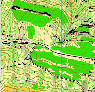
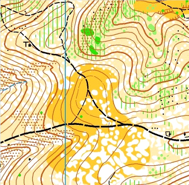
The race takes place in the municipalities of Palacios de la Sierra and Moncalvillo, in the latter municipality was held the I Trophy Valle del Arlanza in 2021, in the terrain through which the race runs can be distinguished several areas. In the centre-west of the map there are relatively gentle limestone hillocks populated by junipers, which are very easy to walk. In the eastern part is the highest point of the map (1370m) where we also have a practically impenetrable pine forest. In the northern part of the map there is a charming and welcoming canyon carved in sandstone and conglomerate by the untiring Ciruelos river for millennia, here we have the lowest point of the map (980m) and bordering the entire northern area of the map, the valley of the Arlanza river, which gives its name to the trophy.
In the rest of the terrain we find hills, slopes, valleys and ledges of all colours full of oak, scrub and steppe, alternating in some areas with small meadows and beautiful pastures that make progress and navigation much easier, The southern area is completely covered with vegetation, pines and oak and in the centre of the map the wonderful centenary oak grove of Palacios with its meadow, its cattle and the Abejón river, in the east of the map the pines and holm oaks predominate, areas that are very easy to walk through. The terrain is very attractive but at the same time demanding, not only because of its orography but also because of its lush vegetation in some corners of the map.
On the dates when the event takes place, the terrain presents a great variety of nuances, going from covered and easy to run areas to others with more unevenness and diverse vegetation. After the summer, we will find that the cattle that graze freely all over the map may have marked new paths and, due to disuse, have abandoned others already drawn on the map, and may be more diffuse in the terrain.
Another aspect to take into account is the vegetation at ground level, which at this time of the year will drop quite a few spikes that will stick to your socks and are quite annoying.
Refreshments
A liquid and solid hash house (HH) refreshment station will be set up next to the finish area. For the race, the participating teams should plan their needs and carry them on their own for the entire duration of the race or make their strategy foreseeing this point.
There are several water points on the terrain as well as in the village squares. If it is necessary due to drought (we hope not), the organisation will add some artificial refreshment points. You will be able to make use of them if you consider it opportune and convenient.
There are 3 types of water points indicated on the map:
- Glass with an asterisk: these are artificial water points.
- Vaso: puntos con agua sin garantías sanitarias.
- Glass with a letter – e.g. (a): seasonal and without guarantees.
In order to reward the visit to these places, at some water points there will be a 3-point control. Also, with the aim of not blurring the map, we reflect them with the symbol that accredits them in the following way: the centre of the control is the water point, which is, obviously, where you will find the beacon, the symbol 713 (glass in brackets) and distanced enough from the control so as not to blur, only gives us information that in that control we will find water (not that the water is precisely in the centre of the symbol 713).
Staff
Competition Director: Teófilo Gil
Technical Director: Carlos Avilés
Head of Security: Javier Contreras
Head of Logistics: Jorge García
Secretary: Natalia Domingo
Head of SportIdent: Pilar Nieto / Jorge Combarros
Course Setting: Bárbara Domingo
FEDO Controller Judge: Jonay Pérez Díaz
Technical Jury: designated on the final bulletin.
Questions and suggestions via our email [email protected].